A massive cavern beneath a West Antarctic glacier is teeming with life
Glaciologists bored 500 meters through the Kamb Ice Stream to access the cavern

Surveys conducted in 2016 at West Antarctica’s lower Kamb Ice Stream revealed a cavern hidden far beneath the surface. At the end of 2021, researchers drilled into it.
H. HORGAN
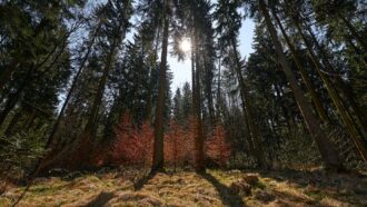
The coastal plain of the Kamb Ice Stream, a West Antarctic glacier, hardly seems like a coast at all. Stand in this place, 800 kilometers from the South Pole, and you see nothing but flat ice extending in every direction. The ice is some 700 meters thick and stretches for hundreds of kilometers off the coastline, floating on the water. On clear summer days, the ice reflects the sunlight with such ferocity that it inflicts sunburn in the insides of your nostrils. It might seem hard to believe, but hidden beneath this ice is a muddy tidal marsh, where a burbling river wends its way into the ocean.
Until recently, no human had ever glimpsed that secret landscape. Scientists had merely inferred its existence from the faint reflections of radar and seismic waves. But in the closing days of 2021, a team of scientists from New Zealand melted a narrow hole through the glacier’s ice and lowered in a camera. They had hoped that their hole would intersect with the river, which they believed had melted a channel up into the ice — a vast water-filled cavity, nearly tall enough to hold the Empire State Building and half as long as Manhattan. On December 29, Craig Stevens finally got his first look inside. It is a moment that he will always remember.
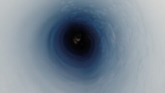
Stevens is a physical oceanographer with New Zealand’s National Institute of Water and Atmospheric Research in Wellington. He spent 90 anxious minutes that day in Antarctica with his head buried ostrich-style under a thick down jacket to block the sunlight that would otherwise obscure his computer monitor. There, he watched live video from the camera as it descended into the hole. Icy circular walls scrolled past, reminiscent of a cosmic wormhole. Suddenly, at a depth of 502 meters, the walls widened out.
Stevens shouted for a colleague to halt the winch lowering the camera. He stared at the screen as the camera rotated idly on its cable. Its floodlights raked across a ceiling of glacial ice — a startling sight — scalloped into delicate crests and waves. It resembled the dreamy undulations that might take millennia to form in a limestone cavern.

“The interior of a cathedral,” says Stevens. A cathedral not only in beauty, but also in size. As the winch restarted, the camera journeyed downward for another half hour, through 242 meters of sunless water. Bits of reflective silt stirred up by currents streamed back down like snowflakes through the black void.
Stevens and his colleagues spent the next two weeks lowering instruments into the void. Their observations revealed that this coastal river has melted a massive, steep-walled cavern cutting as far as 350 meters up into the overlying ice. The cavern extends for at least 10 kilometers and appears to be boring inland, farther upstream, into the ice sheet with each passing year.
This cavity offers researchers a window into the network of subglacial rivers and lakes that extends hundreds of kilometers inland in this part of West Antarctica. It’s an otherworldly environment that humans have barely explored and is laden with evidence of Antarctica’s warm, distant past, when it was still inhabited by a few stunted trees.

One of the biggest surprises came as the camera reached bottom that day. Stevens gazed in disbelief as dozens of orange blurs swam and darted on his monitor — evidence that this place, roughly 500 kilometers from the open, sunlit ocean, is nonetheless bustling with marine animals.
Seeing them was “just complete shock,” says Huw Horgan, a glaciologist formerly at the Victoria University of Wellington who led the drilling expedition.
Horgan, who recently moved to ETH Zurich, wants to know how much water is flowing through the cavern and how its growth will impact the Kamb Ice Stream over time. Kamb is unlikely to fall apart anytime soon; this part of West Antarctica is not immediately threatened by climate change. But the cavern might still offer clues to how subglacial water could affect more vulnerable glaciers.
What’s beneath Antarctica’s ice sheet?
Scientists have long surmised that a veneer of liquid water sits beneath much of the ice sheet covering Antarctica. This water forms as the bottom of the ice slowly melts, several penny-thicknesses per year, due to heat seeping from the Earth’s interior. In 2007, Helen Amanda Fricker, a glaciologist at the Scripps Institution of Oceanography in La Jolla, Calif., reported evidence that this water pools into large lakes beneath the ice and can flood quickly from one lake to another (SN: 6/17/06, p. 382).
Fricker was looking at data from NASA’s Ice, Cloud and Land Elevation Satellite, or ICESat, which measures the height of the ice surface by reflecting a laser off of it. The surface at several spots in West Antarctica seemed to bob up and down, rising and falling by as much as nine meters over a couple of years. She interpreted these active spots as subglacial lakes. As they filled and then spilled out their water, the overlying ice rose and fell. Fricker’s team and several others eventually found over 350 of these lakes scattered around Antarctica, including a couple dozen beneath Kamb and its neighboring glacier, the Whillans Ice Stream.
Where are Antarctica’s subglacial lakes?
Hundreds of subglacial lakes have been found scattered across Antarctica. Samples have been taken from a few (Lake Whillans is shown). Red circles show stable lakes discovered through ice-penetrating radar. Blue triangles show lakes that have been observed draining at least once.

The lakes provoked great interest because they were expected to harbor life and might provide insights about what sorts of organisms could survive on other worlds — deep within the ice-covered moons of Jupiter and Saturn, for instance. The layers of sediment in Antarctica’s lakes might also offer glimpses into the continent’s ancient climate, ecosystems and ice cover. Teams funded by Russia, the United Kingdom and the United States attempted to drill into subglacial lakes. In 2013, the U.S.-led team succeeded, melting through 800 meters of ice and tapping into a reservoir called Subglacial Lake Whillans. It was teeming with microbes, 130,000 cells per milliliter of lake water (SN: 9/20/14, p. 10).
Horgan helped map Lake Whillans before drilling began. But by the time the lake was breached, he and others were becoming intrigued with another facet of the subglacial landscape — the rivers thought to carry water from one lake to another, and eventually to the ocean.
Finding these hidden rivers requires complicated guesswork. Their flow paths are influenced not only by the subglacial topography, but also by differences in the thickness of the overlying ice. Water moves from places where the ice is thick (and the pressure high) to places where it is thinner (and the pressure lower) — meaning that rivers can sometimes run uphill.
By 2015, scientists had mapped the likely paths of several dozen subglacial rivers. But drilling into them still seemed farfetched. The rivers are narrow targets and their exact locations often uncertain. But around that time, Horgan got a lucky break.
While examining a satellite photo of the Kamb Ice Stream, he noticed a wrinkle in the pixelated tapestry of the image. The wrinkle resembled a long, shallow trough in the surface of the ice, as if the ice had sagged from melting beneath. The trough sat several kilometers from the hypothetical path of one subglacial river. Horgan believed that it marked the spot where that river flowed over the coastal plain and spilled into the ice-covered sea.
In 2016, while visiting the area for an unrelated research project, Horgan and his companions detoured briefly to the surface trough to take radar measurements. Sure enough, they found a void under the ice, filled with liquid water. Horgan began making plans to study it more closely. He would return twice in the next few years, once to map the river in detail and a second time to drill into it. What he found greatly exceeded his expectations.
Scientists map a subglacial landscape
Horgan and graduate student Arran Whiteford of the Victoria University of Wellington visited the lower Kamb Ice Stream to map the river in December 2019.
After weeks on the Antarctic ice sheet, they’d grown accustomed to its monotonous flat landscape, their perception sensitized to even tiny ups and downs. In this context, the surface trough “looked like this massive chasm,” Whiteford says, “like an amphitheater” — even though it slanted no more dramatically than a rolling cornfield in Iowa.
It was a week of scientific drudgery, towing the ice-penetrating radar behind a snowmobile along a series of straight, parallel lines that crisscrossed the trough to map the shape of the river channel under the ice.
Horgan and Whiteford worked up to 12 hours per day, occasionally trading positions. One person drove the snowmobile, straining his thumb on the throttle to maintain a constant 8 kilometers per hour. Two sleds hissed along behind. One held a transmitter that fired radar waves into the glacier below; the other held an antenna that received the signal reflected back off the bottom of the ice. The second person rode on the sled with the antenna, his eyes on a bouncing laptop screen making sure that the radar was functioning.

Each evening they huddled in their tent, reviewing their radar traces. The river channel appeared far more dramatic than the gentle dip atop the ice suggested. Below their boots sat a vast water-filled cavern with steep sides like a train tunnel, 200 meters to a kilometer wide and cutting as much as 50 percent of the way up through the glacier. The more they looked, the more it resembled a river. “It kind of meanders downstream,” Whiteford says.
All told, Whiteford made two weeklong visits to the trough, snowmobiling over from another camp 50 kilometers away. The first time he was accompanied by Horgan, and the second time by another graduate student, Martin Forbes.
After returning home to New Zealand in January 2020, Whiteford examined a series of old satellite images. They showed that the surface trough — and hence, the cavern — had begun forming at least 35 years before, starting with a blip at the very mouth of the river, where it ran into the ocean. That blip had gradually lengthened, reaching progressively farther inland, or upstream. Whiteford and Horgan reported the observations in late 2022 in the Journal of Geophysical Research: Earth Surface — along with their theory about how the cavern formed.
In other parts of Antarctica where the ice sheet protrudes off the coastline, scientists have found that the ice’s underside is often insulated from the ocean heat by a buoyant layer of colder, fresher meltwater. That protective layer is sometimes only a couple of meters thick. But Horgan and Whiteford suspect that the turbulence of the subglacial river flowing into the ocean stirs up that protective layer, causing seawater — a few tenths of a degree warmer than the subglacial water — to swirl up into contact with the ice. This causes an area of concentrated melt right at the river’s mouth, creating a small cavity where warm seawater can intrude further.
In this way, says Horgan, the focal point of melting is “stepping back over time.” And the cavern gradually burrows farther upstream into the ice.
Whiteford used a different set of satellite measurements — which measured the rate at which the ice’s surface sank over time — to determine how quickly the ice was melting in the cavern below. Based on this, he estimated that in the upstream end of the cavern, the ice (currently 350 to 500 meters thick over the channel) was melting and thinning 35 meters per year. That’s an astronomical rate. It’s 135 times what has been measured 50 kilometers southwest of the cavern, where the ice floats on the ocean. The water temperature is probably similar at both locations. But the turbulence caused by the river transfers the water’s heat far more efficiently into the ice.
Horgan thinks that the cavern at Kamb also owes its dramatic height to another factor. Glaciers in this part of West Antarctica generally flow several hundred meters per year. So the melt caused by a flowing river beneath, over years or decades, would normally be spread out over a long swath of ice. This would erode a shallow channel rather than a deep cleft. But Kamb is an oddball. Around 150 years ago, it stopped moving almost entirely due to the cyclical interplay of melting and freezing at its base. It now creeps forward only about 10 meters per year. The melting is thus concentrated, year after year, in almost the same spot.
Back in 2020, all of this was still conjecture. But if Horgan and his colleagues could return, drill into the cavern and lower instruments into it, they could confirm how it formed. By studying the water, sediment and microbes flowing out of it, they could also learn a lot about Antarctica’s vast subglacial landscape.
The West Antarctic Ice Sheet covers an area three times the size of the Colorado River drainage basin, which sprawls across Arizona, Utah, Colorado and parts of four other states. To date, humans have observed only a tiny swath of this underworld, smaller than a basketball court — represented by several dozen narrow boreholes scattered across the region, where scientists have grabbed a bit of mud from the bottom or sometimes lowered in a camera.
Horgan was eager to explore more. With New Zealand already melting boreholes through ice floating on the ocean, drilling into this coastal river seemed like a natural next step.
How did the hidden cavern form?
On December 4, 2021, a pair of caterpillar-tracked PistenBullys arrived at the place where Horgan and Whiteford had visited two years before. The tractors had traveled for 16 days from New Zealand’s Scott Base on the edge of the continent, growling across a thousand kilometers of floating ice as they towed a convoy of sleds packed with 90 metric tons of food, fuel and scientific gear. The convoy lumbered around to the upstream end of the valley and stopped.
Workers erected a tent the size of a small aircraft hangar, and inside it, assembled a series of water heaters, pumps and a kilometer of hose — a machine called a hot water drill. Using shovels and a small mechanized scooper, they dumped 54 tons of snow into a tank and melted it. The workers then jetted that hot water through the hose, using it to melt a narrow hole, no wider than a dinner plate, through 500 meters of ice — and down through the domed ceiling of the cavern.
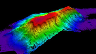
The cavern’s size and shape
This 3-D rendering shows the shape of the cavern, based on radar traces. Scientists think it is being carved back from the coastline as a river flowing beneath the ice meets the ocean and stirs up the water there. The 2-D illustration shows what a rough cross section at one point might look like, with ice above and ground beneath.

The sight of animals inside the cavern generated instant excitement among Horgan, Stevens and the other people at camp. But those first images were blurry, leaving people unsure of what the orange, bumblebee-sized critters actually were.
Workers next lowered an instrument down the borehole to measure the water temperature and salinity inside the cavern. They found the top 50 meters of water colder and fresher than what lay below — confirming that seawater was flowing in along the bottom and a more buoyant mixture of saltwater and freshwater was flowing out along the top. The cavern, says Stevens, “is operating quite like an estuary.”
But those measurements also presented a mystery: The water in the top of the cavern was only about 1 percent less salty than the seawater in its bottom, suggesting that the amount of freshwater flowing in through the river was “quite small,” says Stevens. It’s akin to a shallow creek that a young kid might splash around in. He and Horgan doubted that the turbulence caused by this small flow, even over 35 years, could melt the entire cavern — roughly a cubic kilometer of ice.
A likely answer came from a set of samples collected from the floor of the cavern. Gavin Dunbar, a sedimentologist at the Victoria University of Wellington, lowered a hollow plastic cylinder down the hole in hopes of retrieving a core. As he and graduate student Linda Balfoort hoisted the cylinder back up, they found it streaked and filled with chocolaty mud — a strange sight in this world of pure white, where not a speck of rock or dirt can be seen for hundreds of kilometers.
As Dunbar and Balfoort X-rayed and analyzed the cores months later, back in New Zealand, their peculiarities became obvious: They were unlike anything that Dunbar had ever encountered in this part of the world.
Every core that Dunbar had ever seen from the seafloors near this part of Antarctica consisted of a chaotic jumble of sand, silt and gravel — a material called diamict, formed as the ice sheet advances and retreats over the seafloor, plowing and mixing it like a rototiller. But in these cores, Dunbar and Balfoort saw distinct layers. Bands of coarse, gravely material were interspersed with layers of fine, silty mud.
That alternating pattern resembled samples from steep seafloor canyons off the coast of New Zealand, where earthquakes sometimes trigger underwater landslides that sweep for many kilometers downhill. Each flood deposits a single layer of chunky material.
Dunbar believes that something similar happened under the Kamb Ice Stream, possibly in the last few decades. A series of fast-moving torrents gushed through the river channel carrying big gravelly chunks from somewhere upstream that later settled on the cavern floor. “Each of these [coarse layers] represents minutes to hours of sediment deposition” that occurred during a single flood, he says. And the fine, silty layers would have been laid down over years or decades in between the floods, when the river flowed languidly along.
These subglacial floods could explain how this small river carved such a large cavern, Stevens says. Those floods could have been 100 to 1,000 times as large as the flow rates that were measured during the 2021–22 field season.
No one knows when those events happened, but scientists using satellites to study subglacial lakes have spotted at least one candidate. In 2013, a lake 20 kilometers upstream from the cavern, called KT3, disgorged an estimated 60 million cubic meters of water — enough to fill 24,000 Olympic-sized swimming pools.
Scientists would love to know whether that flood actually passed through this cavern. “Connecting this upstream to the lake system would be extremely cool,” says Matthew Siegfried, a glaciologist at the Colorado School of Mines in Golden, who coauthored one of the reports documenting the 2013 flood.
Studying the outflow of this river could also answer other questions about the subglacial landscape upstream. “The vast majority of our knowledge of subglacial lakes comes from surface observations from space,” Siegfried says. But those satellite records, of ice bobbing up and down, permit only indirect estimates of how much water is flowing through. It’s possible, for example, that a lot of water passes through the lakes even when the ice above isn’t moving.
Scientists could also learn about the subglacial landscape by studying the sediment washed downstream. When Dunbar and his colleagues examined the coarse material from their cores, they found it full of microscopic fossils: glassy shells of marine diatoms, needly spicules of sea sponges, and notched and spiky pollen grains of southern beech trees. These fossils represent the remains of a warmer world, 15 million to 20 million years ago, when a few stands of stunted, shrubby trees still clung to parts of Antarctica. Back then, the West Antarctic basin held a sea rather than an ice sheet, and this detritus settled on its muddy bottom. These old marine deposits underlie much of the West Antarctic Ice Sheet, and the few boreholes drilled so far suggest that the mix of fossils differs from one place to another. Those mixes could provide clues to how the flow of rivers changes over time.
To uncover the nuance of what’s happening in the cavern “is mind-blowingly cool,” says Christina Hulbe, a glaciologist at the University of Otago in Dunedin, New Zealand, who has studied this region of Antarctica for nearly 30 years. “That’s the outlet for a massively big river system, if you think about it.”
By studying the water, scientists could estimate the amount of organic carbon and other nutrients flowing out of the river into the ice-covered ocean. The landscape beneath the ice sheet appears to be rich in nutrients that might sustain oases of life in an otherwise famished biological desert.
Scientists unveil an oasis of life
Even as the cavern penetrates farther into the Kamb Ice Stream, it does not necessarily threaten the glacier’s stability. This part of the West Antarctic coastline is not considered vulnerable, because its shallow bed shields it from the deep, warm ocean currents that are causing rapid ice loss in other regions. But subglacial rivers pour out at many other points along the coastline, including some — like Thwaites Glacier, roughly 1,100 kilometers northeast of Kamb — where the ice is retreating rapidly (SN: 3/11/23, p. 8).
Thwaites and nearby glaciers have collectively shed over 2,000 cubic kilometers of ice since 1992. They could eventually raise global sea levels by 2.3 meters if they collapse. Remote sensing studies have documented over a dozen low, squat shield volcanoes beneath this part of the ice sheet. The elevated geothermal heat flow, even from inactive volcanoes, is thought to cause high levels of melting under the ice sheet. That melting produces large amounts of subglacial water, which could render these glaciers even more vulnerable to human-caused climate change.
Horgan believes that what scientists learn at Kamb could improve our understanding of how subglacial rivers impact those other, rapidly changing coastlines of Antarctica.
But the most evocative discovery made at Kamb — in purely human terms — may be the blurry, orangish animals seen swarming near the bottom of the cavern. Stevens captured some clearer images a few days later and tentatively identified them as shrimplike marine crustaceans called amphipods. To see so many of them here, Stevens says, “we really hadn’t expected that.”
Microbes like those previously found under the ice sheet in Subglacial Lake Whillans are known to eke out a living even in harsh conditions. But animals are a different matter. The deepest seafloors on Earth sit only 10 or 11 kilometers from sunlight, and animal life in those places is generally scarce. But the animals in the cavern are thriving 500 kilometers from the nearest daylight, cut off from the photosynthesis that fuels most life on Earth.
The amphipods and their supporting ecosystem must be subsisting on some other food source. But what? Observations in the Kamb ice cavern, combined with those at two other remote boreholes drilled in recent years, offer some tantalizing hints.
In 2015, researchers pierced the ice at another site 250 kilometers from the cavern, where the Whillans Ice Stream lifts off its bed and floats. In that location, a thin sliver of seawater, just 10 meters deep, sits beneath 760 meters of ice. A remotely operated vehicle, or ROV, sent down the hole captured images of fish and amphipods.
John Priscu, a microbial ecologist at Montana State University in Bozeman who was involved in the drilling at the site, believes that the glacier itself is sustaining this ecosystem. The bottom 10 meters of ice is packed with mud that had frozen onto the belly of the glacier many kilometers upstream. The mud had been dragged to its present location as the glacier oozed forward, 400 meters per year. As the ROV navigated about, bits of that muddy debris constantly rained down, released as the ice’s underside slowly melted. That debris is rich in organic matter — the rotting remains of diatoms and other phytoplankton that sank to the bottom millions of years ago when the world was warmer.
“Those amphipods are swarming to the particulate matter,” Priscu says. “They’re sensing the organic matter falling out of that basal ice.” Or perhaps they may be eating the bacteria that live on those organics.
Because the Kamb Ice Stream is barely moving, the supply of dirty ice moving toward the sea is small. But the river flowing into the ice cavern may deliver the same subglacial nutrients that are found in dirty ice. After all, the water’s journey through a series of subglacial lakes down to the river’s mouth may take years or decades. Throughout that time, the river absorbs nutrients from the organic-rich subglacial sediments.
Indeed, when scientists drilled into Subglacial Lake Whillans in 2013, they found its water honey-colored — chock-full of life-sustaining iron, ammonium and organics. “What these lakes are pumping out may be a concentrated source of nutrients” for ecosystems along the dark coastline, says Trista Vick-Majors, a microbial ecologist at Michigan Technological University in Houghton who was involved in the drilling at Lake Whillans. She has estimated that the subglacial rivers flowing out from under Kamb and its neighboring glaciers may deliver 56,000 tons of organic carbon and other nutrients to this section of the coastline every year.
More recently, in December 2019, a team from New Zealand led by Horgan and Hulbe drilled through the ice just 50 kilometers from the Kamb cavern, in a place where the Kamb Ice Stream floats on the ocean. There’s no dirty ice there and no nearby river outlets. The area resembled a famished seafloor desert; it was populated by single-celled microbes with little to eat, and few signs of animals were seen — only a few burrowing traces on the muddy bottom. Priscu sees this location as an exception that proves the point: Subglacial nutrients are the crucial energy source in this dark world under the floating ice, whether they are dragged forward on the undersides of glaciers or spilled out through subglacial rivers.
The mud and water samples collected from the Kamb ice cavern may provide a new opportunity to test that theory. Craig Cary, a microbial ecologist at the University of Waikato in New Zealand, is analyzing DNA from those samples. He hopes to determine whether the microbes in the cavern belong to taxonomic groups that are known to subsist on ammonium, methane, hydrogen or other sources of chemical energy that originate from the subglacial sediments. That might reveal whether such sources support enough microbial growth to feed the animals observed there.
The team also needs to measure the flow rate of the subglacial river that spills into the cavern, since that determines the nutrient supply. Stevens continues to monitor this thanks to a set of instruments left behind in the cavern.

As people were packing up camp on January 11, 2022, workers pumped more hot water into the borehole, widening it to more than 35 centimeters — and creating a dangerous pitfall. Stevens and his colleagues donned climbing harnesses, clipped into safety ropes and approached the hole one last time. They lowered a series of cylinders the size of caulking guns down the hole. These devices continue to measure the temperature, salinity and water currents inside the cavern, sending the data 500 meters up a cable to a transmitter that beams it home via satellite once a day. That data will reveal how the river’s flow changes over time. With luck, the instruments might even detect a subglacial flood gushing through.
“That would just be outstanding,” Horgan says. For many years, he had to content himself with seeing these rivers and lakes dimly, through the outlines of water on radar and satellite images. This is “one of the first times we’ve got to stand at a river mouth and observe it.”